Accessibility/Remoteness Index of Australia (ARIA+)
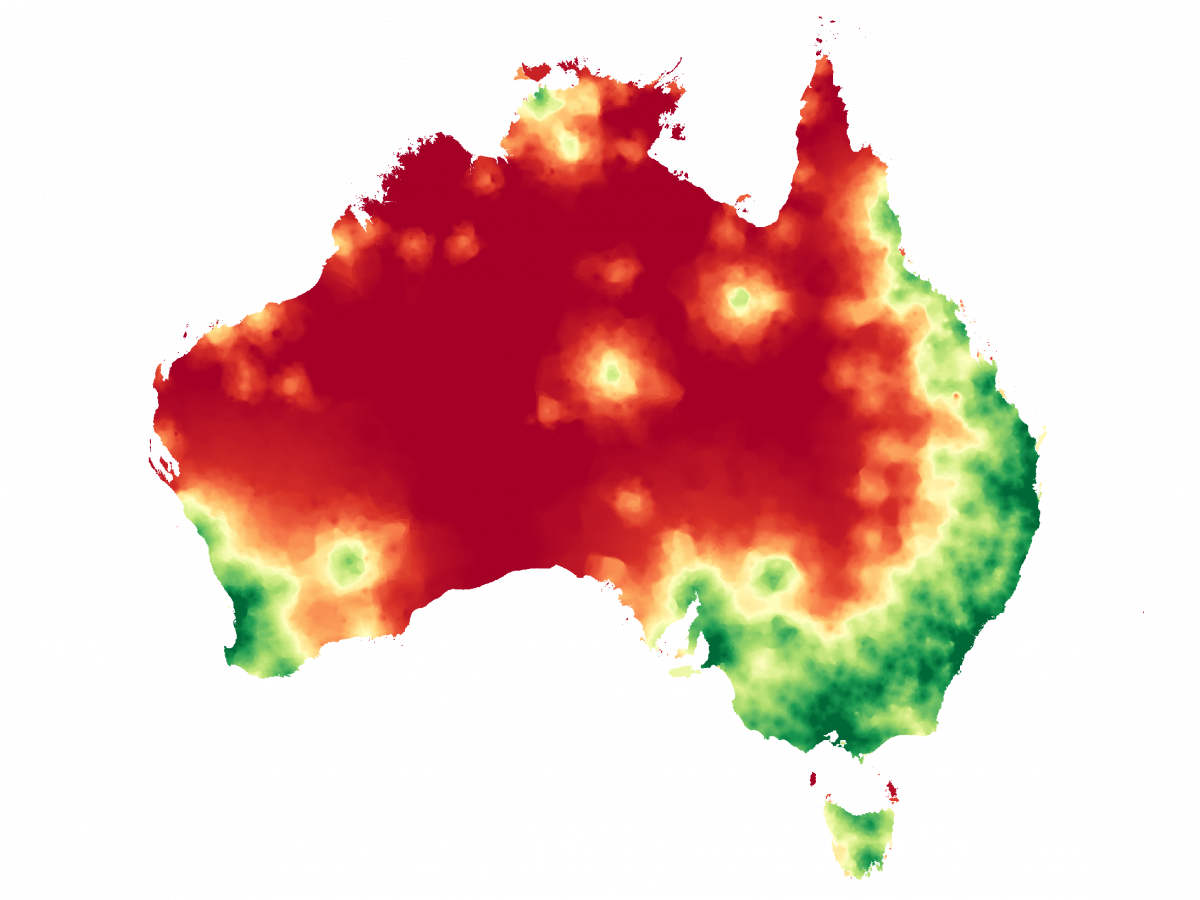
The Accessibility/Remoteness Index of Australia (ARIA+) is the leading Australian indicator of remoteness. For the last two decades, it has been the official classification of remoteness used by the Australian Bureau of Statistics (ABS).
ARIA+ is a continuous index with values ranging from 0 (high accessibility) to 15 (high remoteness). Scores are based on road distance measurements from over 12,000 populated localities to population centres across Australia.
The resulting index is a 1-kilometre grid covering the whole of Australia from which accessibility/remoteness values can be extracted for any geographic location of interest.
-
Advantages of ARIA+
The major advantages of ARIA+ over other methods of measuring remoteness are:
- it provides a nationally consistent measure of accessibility/remoteness, allowing the accurate comparison of any locations across the whole of Australia;
- it is a purely geographic measure of remoteness, which excludes any consideration of socio-economic status, 'rurality' and populations size factors (other than the use of breaks in the population distribution of Urban Centres to define the Service Centre categories);
- it is flexible and can be aggregated to a range of spatial units, used as a continuum or classified;
- its methodology is conceptually clear;
- it is precise; and,
- it is relatively stable over time.
As a comparable index of remoteness that covers the whole of Australia, ARIA provides a measure of remoteness that is suitable for a broad range of applications including assisting in service planning, demographic analysis and resource allocation.
ARIA provides a remoteness, or accessibility, value for every location in Australia (to two decimal places), and can be purchased for Australian Bureau of Statistic (ABS) geographies and non-ABS geographies (eg Local Government Areas) as well as scores of each populated locality/town used in the creation of the index.
-
Methodology
ARIA+ measures remoteness in terms of access along the road network from populated localities to each of five categories of Service Centre based on population size, as indicated in the below table. If one thinks of ARIA as based on the distances people have to travel to obtain services, then populated localities are where they are coming from, and Service Centres are where they are going to.
Service Centre Category Urban Centre Population A 250,000 persons or more B 48,000 - 249,999 persons C 18,000 - 47,999 persons D 5,000 - 17,999 persons E 1,000 - 4,999 persons F (ARIA++ only) 200 - 999 persons The ARIA+ methodology regards services as concentrated into Service Centres. Localities with populations greater than 1,000 persons are considered to contain at least some basic level of services (e.g. health, education, or retail). As such these towns and localities are regarded as Service Centres. Service Centres with larger populations are assumed to contain a greater level of service provision.
The road distance from each of the 12,000+ populated localities to the boundary of the nearest Service Centre in each category was calculated. This calculation resulted in five distance measurements being recorded for each populated locality (one for each Service Centre category). Populated towns within a Service Centre (based on ABS-defined Urban Centre boundaries) in the relevant category were given a distance value of zero for that category. Each distance value was divided by the Australian average (mean) for that category in order to derive a standardised (or ratio) value. Distance measurements are standardised so that large distance measurements would not overwhelm the effect of the other distance measurements.
Each ratio value is thresholded at three (i.e. three times the Australian mean) to remove the effects of any remaining extreme values from the index. All towns with a ratio value higher than three for a given category are considered 'remote' in terms of access to that category and were given a value for that category equal to the threshold. For each populated locality, the standardised value from each of the five Service Centre categories is summed to produce an overall index value ranging between 0 and 15. The lower the value, the greater the access to services.
An interpolation procedure is then used to derive the index values for each of the localities to a 1-kilometre grid so that all areas of Australia are able to be assigned an index value.
-
Example calculation
The example below shows how the ARIA+ 2021 score for Pine Creek is calculated*.
The locality of Pine Creek in the Northern Territory is:
- 2,818 km from the nearest Category A Service Centre (Adelaide)
- 206 km from the nearest Category B Service Centre (Darwin)
- 206 km from the nearest Category C Service Centre (Darwin)**
- 91 km from the nearest Category D Service Centre (Katherine)
- 91 km from the nearest Category E Service Centre (Katherine)***
Next, distances are divided by the national average for each category:
- Its Category A score is 2,818 / 412 (national average for category A) = 6.84 {exceeds threshold so score = 3.00}
- Its Category B score is 206 / 214 = 0.96
- Its Category C score is 206 / 133 = 1.55
- Its Category D score is 91 / 88 = 1.03
- Its Category E score is 91 / 46 = 1.98
The ARIA score is thus 3.00 + 0.96 + 1.55 + 1.03 + 1.98 = 8.52
Although ARIA+ provides a measure of accessibility and remoteness for the whole of Australia, including metropolitan and non-metropolitan areas, the principal focus of the index has been to quantify accessibility in non-metropolitan Australia.
* Please note that rounding has been applied for the purpose of this example. This example does not reflect the actual ARIA score of Pine Creek, Northern Territory.
** There were no Category C Service Centres closer to Pine Creek than Darwin, so Darwin functions both as the closest Class B, and the nearest Class C service centre.
*** There were no Category E Service Centres closer to Pine Creek than Katherine, so Katherine functions as both the closest Class D and Class E centre
Purchase ARIA Data
The ACHR distributes two versions of ARIA (ARIA+ & ARIA++) with ARIA 2021 being the most recent data release.
For more information, please contact us.